Health index
TA ČR Project – Program to support applied social science and humanities research, experimental development and innovation ETA
Inequalities in health in the Czech Republic: Importance and Relationship of Health Determinants of the Population in Territorial Disparities (HINEQ) TL03000202
The Health Index presented here offers a comprehensive view of regional differences in inequalities in health without the need to look at many separate indicators. The Index reduces the size of the original set of determinants, which enables its comprehensible and easy interpretation, including its spatial differentiation. As a result, the results can be a useful basis for decision-making by state and local governments or other organizations dealing with population health issues.
The health index is created in four variants: multi-criteria decision-making methods (WSA and TOPIS) are used for the analyses and each method presents the results in two variations (1. all determinants have the same weight and 2. determinants are assigned different weights). The methods are detailed here. The index enables summarizing and interpreting a larger number of determinants and health indicators, health status and quality of life in the districts of the Czech Republic. It is composed of eight areas and contains a total of 60 indicators.
The aim of the project is to increase and broaden the possibilities of applying knowledge about the determinants of population health in the regions of the Czech Republic. The outputs of the project will provide information and data to promote health equity and overall health of the population of the Czech Republic in one place. The developed software allows the input of historical and future data according to defined periods, statistically processes the input data and visualizes the results.
Solution Period
04/2020 – 12/2021
Project Coordinator Mendel university in Brno
Project partner Masaryk university

Project objectives
- To select, classify and quantify relevant determinants of health and health indicators of the population of the Czech Republic at the regional level of districts and selected localities in their territory differentiation.
- Identify the interrelationship of health areas and determinants and clarify their relevance to the quality of life of the population.
- Identify the main causes of inequalities in health at both the macro (structural) and micro (individual) levels.
- Identify locations and population groups with inequalities in health, define their socio-economic, demographic, environmental and individual causes.
- Apply the results to targeted intervention activities in the area of reducing inequalities in health at the regional and national level and use the results to raise awareness of the causes of inequalities in health.
PhDr. Dana Hübelová, PhD.
+420 734 509 405
hubelova@mendelu.cz
Methodology and indicators
The methodological approach of the project is based on the use of social science methods, which are extended by methods of natural sciences and technical disciplines (visualization in ArcGIS, statistical and mathematical procedures, IT technologies for software, etc.).
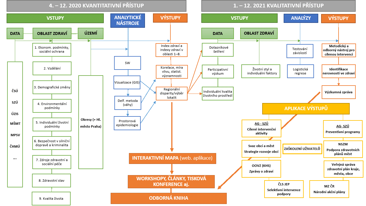
Areas and dimensions of health
A separate index is calculated for each area and a Health Index is created from the data of areas 1 to 8. In addition, in area 9, sub-indices within the area itself are presented. The weights were determined by interdisciplinary expert decision making using the Delphi method.
1. Economic conditions and social protection
The Index of Economic Conditions and Social Protection summarizes a larger number of indicators, allows for a clear and easy interpretation of the results and presents their territorial differences in 77 districts of the Czech Republic. It reduces the size of the original set of 14 indicators to a single value expressed by the Index of Economic Conditions and Social Protection. The indicators of economic and social conditions that are included in the index may give rise to inequalities in health.
The index of economic conditions and social protection enables ranking individual regions (districts) according to their scores, based on the principle that the higher its value, the better the scores achieved. The results in the maps are interpreted in the same way, with a darker shade always indicating a better score.
The Economic Conditions and Social Protection Index is composed of three dimensions:
Employment expressed as a share of total unemployed and share of unemployed by sex for the age group 15-64 years. Furthermore, by the share of jobseekers in selected age groups, namely 50-64 and 15-24 years, by the share of jobseekers with a duration of unemployment of 12 months or more, and by the share of jobseekers with primary and secondary vocational education without matriculation.
Living conditions and social benefits presented by gross domestic product per capita, the share of housing benefits for people aged 20 and over and the share of child benefits for people aged 20-59.
The class scheme includes persons aged 18 and over and is composed of a total socioeconomic index and a socioeconomic index by gender, assessed according to the ISEI-08: International Socio-Economic Index of Occupational Status, which measures the socioeconomic status of occupations. It is based on a combination of the education required for an occupation and the average income that occupation brings. Values range on a scale of 10 to 90.
Data for each indicator come from publicly available databases of the Czech Statistical Office (2018), the Ministry of Labour and Social Affairs of the Czech Republic (2019) and the Czech Household Panel Survey (2018).
2. Education
The Education Index aggregates multiple indicators into a single value that makes the results easy to understand and interpret. The map presents the results of the Education Index in territorial disparities at the level of 77 districts of the Czech Republic. Disparities in educational attainment are key to the emergence of inequalities in health and quality of health and life.
The Education Index enables ranking the regions (districts) according to their scores, based on the principle that the higher the value, the better the scores. The results in the maps are interpreted in the same way, with a darker shade always indicating a better score.
The Education index is a composite of the dimensions:
Educational structure, which includes the shares of persons with primary education, including incomplete primary education, and the shares of persons with completed tertiary education, always for the age category 15 and over.
Data for individual indicators come from the Czech Statistical Office database (Census of Population, Houses and Flats, 2011).
- Demographic changes
The Demographic Change Index summarizes a larger number of indicators, allowing for a clear and easy interpretation of the results. The map presents territorial differences in the index values in 77 districts of the Czech Republic. It reduces the size of the original set of indicators into a single value expressed by the Demographic Change Index. The indicators included in the index may influence health quality and inequalities in health.
The Demographic Change Index allows to rank individual regions (districts) according to the values achieved, based on the principle that the higher its value, the better the results of the assessment. The results in the maps are interpreted in the same way, with a darker shade always indicating a better score.
The Demographic Change Index is composed of three dimensions:
Migration expressed as a proportion of foreigners by the five most common citizenships relative to the total population.
Ageing mediated by the age index as a ratio of the post- and pre-productive population (number of persons aged 65 and over to the number of persons aged 0-14).
Urbanization presented through the urbanization rate (proportion of population living in cities).
Data for individual indicators are from the Czech Statistical Office database (2019).
3. Demographic changes
The Demographic Change Index summarizes a larger number of indicators, allowing for a clear and easy interpretation of the results. The map presents territorial differences in the index values in 77 districts of the Czech Republic. It reduces the size of the original set of indicators into a single value expressed by the Demographic Change Index. The indicators included in the index may influence health quality and inequalities in health.
The Demographic Change Index allows to rank individual regions (districts) according to the values achieved, based on the principle that the higher its value, the better the results of the assessment. The results in the maps are interpreted in the same way, with a darker shade always indicating a better score.
The Demographic Change Index is composed of three dimensions:
Migration expressed as a proportion of foreigners by the five most common citizenships relative to the total population.
Ageing mediated by the age index as a ratio of the post- and pre-productive population (number of persons aged 65 and over to the number of persons aged 0-14).
Urbanization presented through the urbanization rate (proportion of population living in cities).
Data for individual indicators are from the Czech Statistical Office database (2019).
4. Environmental conditions
The environmental conditions index presents territorial differences in air quality, which is expressed by the concentration of selected main pollutants, and in the ecological stability of the territory. The index includes six indicators. Five of them reflect air quality and one the ecological stability of the landscape, for all districts of the Czech Republic. The indicators of the Environmental Conditions Index may cause inequalities in health within the Czech Republic.
The Environmental Conditions Index ranks the individual regions (77 districts) of the Czech Republic according to the values achieved, on the principle that the higher its value, the more favorable the environmental conditions of the region. The results are interpreted in the same way in the maps, where a darker shade always indicates better conditions.
The Environmental Conditions Index is composed of two sub-dimensions:
Air quality is expressed in terms of average concentrations of selected pollutants affecting the health of the population. Specifically, these are concentrations of PM2.5, PM10 suspended particulate matter, PM2.5, PM10, NO2, benzo[a]pyrene and benzene. PM refers to mixtures of various solid and liquid particles suspended in the air, sometimes referred to as dust particles or aerosols, the number then denotes the maximum diameter of the particle in micrometers and the concentration is given in µm/m3 of air. Similarly, the concentration of NO2 (nitrogen dioxide) is given in µm/m3 of air. Benzo[a]pyrene (BaP) is the name given to a carcinogenic polycyclic aromatic hydrocarbon that binds to PM2.5. Benzene belongs to the group of potentially carcinogenic aromatic hydrocarbons.
The ecological stability of the landscape is presented by the ecological stability coefficient, which expresses the proportion of ecologically stable areas (forests, gardens, orchards, permanent grasslands, water areas) and ecologically unstable areas (arable land, built-up and other areas).
Data for individual indicators come from publicly available databases of the Czech Statistical Office (CSO, 2019) and the Czech Hydrometeorological Institute (CHMI, 2019).
5. Individual living conditions
The Individual Living Conditions Index summarizes selected indicators into an index that allows for a clear interpretation of territorial differences in living conditions of the population at the level of all districts of the Czech Republic. The indicators of the Individual Living Conditions Index may cause Inequalities in health within the Czech Republic.
The Index of Individual Living Conditions ranks the 77 districts of the Czech Republic according to their values, the higher the value, the more favorable the individual living conditions in the region. The results in the maps are interpreted in the same way, with a darker shade always indicating better conditions.
The individual well-being index is composed of two sub-themes:
Housing conditions are expressed by two indicators, namely the average area of living space per person (m2) and the proportion of ecologically (electricity, gas) and non-ecologically (solid fuels) heated residential buildings in the district.
Technical infrastructure is represented by the value of the share of municipalities in the district with a connection to a sewerage system ending with a wastewater treatment plant.
Data for individual indicators come from publicly available databases of the Czech Statistical Office (CSO SDLB, 2011 and CSO Sample Survey, 2016).
6. Road safety and crime
The Road Safety and Crime Index summarizes multiple indicators, making the results easy to understand and interpret. The map presents territorial differences in the index values in 77 districts of the Czech Republic. It reduces the size of the original set of five indicators into a single value expressed by the Road Safety and Crime Index. The road safety conditions and crime data included in the index can affect the quality of life.
The Road Safety and Crime Index enables ranking individual regions (districts) according to their scores, based on the principle that the higher its value, the better the scores achieved. The results are interpreted in the same way in the maps, where a darker shade always means a better value achieved.
The Road Safety and Crime Index is composed of two dimensions:
Traffic crashes, which include the proportions of traffic crashes relative to the size of the population, the proportions of alcohol-impaired crashes, and standardized traffic crash fatality rates.
The crime rate works with a standardized rate of deaths due to assault (attack) and the proportion of registered crimes relative to the size of the population.
Data for individual indicators are from the Czech Statistical Office (2018) and the Institute of Health Information and Statistics of the Czech Republic (2017). Standardised mortality rates are based on the European Population Standard (ESP2013).
7. Health and social care resources
The Health and Social Care Resource Index aggregates multiple indicators, making the results easy to understand and interpret. The map presents territorial differences in the index values in 77 districts of the Czech Republic. It reduces the size of the original set of indicators into a single value expressed by the Health and Social Care Resource Index. The health and social care capacity data included in the index can affect the quality of life of the population and cause inequalities in health.
The Health and Social Care Resource Index allows for the ranking of regions (districts) according to their scores, based on the principle that the higher the value, the better the scores. The results in the maps are interpreted in the same way, with a darker shade always indicating a better value achieved.
The Health and Social Care Resource Index is a composite of the dimensions:
Health and social care capacities are expressed in terms of the proportion of doctors in health care facilities, the proportion of beds in hospitals and the proportion of places in social service facilities, always relative to the population.
Data for individual indicators are from the Czech Statistical Office (2018).
8. Health status
The Health Status Index summarizes a larger number of indicators, making the results easy to understand and interpret. The map presents territorial differences in the index values in 77 districts of the Czech Republic. It reduces the size of the original set of 24 indicators to a single value expressed by the Health Status Index. The indicators included in the index present territorial differentiations in the quality of health status of the population.
The Health Status Index enables ranking individual regions (districts) according to their scores, based on the principle that the higher its value, the better the scores achieved. The results in the maps are interpreted in the same way, with a darker shade always indicating a better score.
The Health Status Index is composed of four dimensions:
The life expectancy and mortality structure consists of life expectancy at birth by sex, life expectancy at age 65 by sex, standardised death rates by sex, standardised death rates from infectious and parasitic diseases, diseases of the circulatory, respiratory and digestive systems and neoplasms, standardised death rates from external causes and from deliberate self-harm by sex. In addition, the topic is composed of infant and neonatal mortality rates. Deaths caused by inappropriate lifestyle behaviors are included, as are standardized rates of deaths due to liver disease and tobacco smoking.
The abortion components of the topic are indicators of spontaneous abortion and induced abortion.
Diabetes presented by the proportion of treated diabetics in the total population.
The maturity of a child at birth, mediated by the proportion of children with a birth weight up to 2 500 g relative to all live births.
Data for individual indicators are from the databases of the Czech Statistical Office (2018, 2019) and the Institute of Health Information and Statistics of the Czech Republic (2017). Standardised mortality rates are based on the European Population Standard (ESP2013).
9. Quality of life
The Quality of Life Index summarizes multiple indicators, making the results easy to understand and interpret. The map presents territorial differences in the index values in 77 districts of the Czech Republic. It reduces the size of the original set of five districts into a single value expressed by the Quality of Life Index. The Quality of Life Index represents regional differences based on two dimensions: subjective well-being and subjective health status.
The Quality of Life Index enables ranking individual regions (districts) according to their scores, based on the principle that the higher its value, the better the scores achieved. The results are interpreted in the same way in the maps, where a darker shade always means a better value achieved.
The Quality of Life Index is composed of two dimensions:
Subjective well-being is measured on the basis of two dimensions: a) cognitive component: satisfaction with life; b) affective component: happiness. The values included in the index are defined as the average values of the total adult population in 2018. In particular, the average values for the male and female adult population in the same reference year are also presented.
Subjective health status is multidimensional and based on an assessment of multiple aspects of one’s own health. This indicator is operationalized by 4 indicators: self-assessment of (personal) health status, habits, functional and physical status, and mental health. The values presented are percentages (in percentages).
The data for each indicator come from the Czech Society Proměny (CHPS) research project, which is an interdisciplinary household survey. For the purpose of calculating the index, data from the 4th wave of 2018 were used.